摄影原作结合等高线地形图设计海报
来源: @Hamburgerai模型: ChatGPT
📸 示例图片
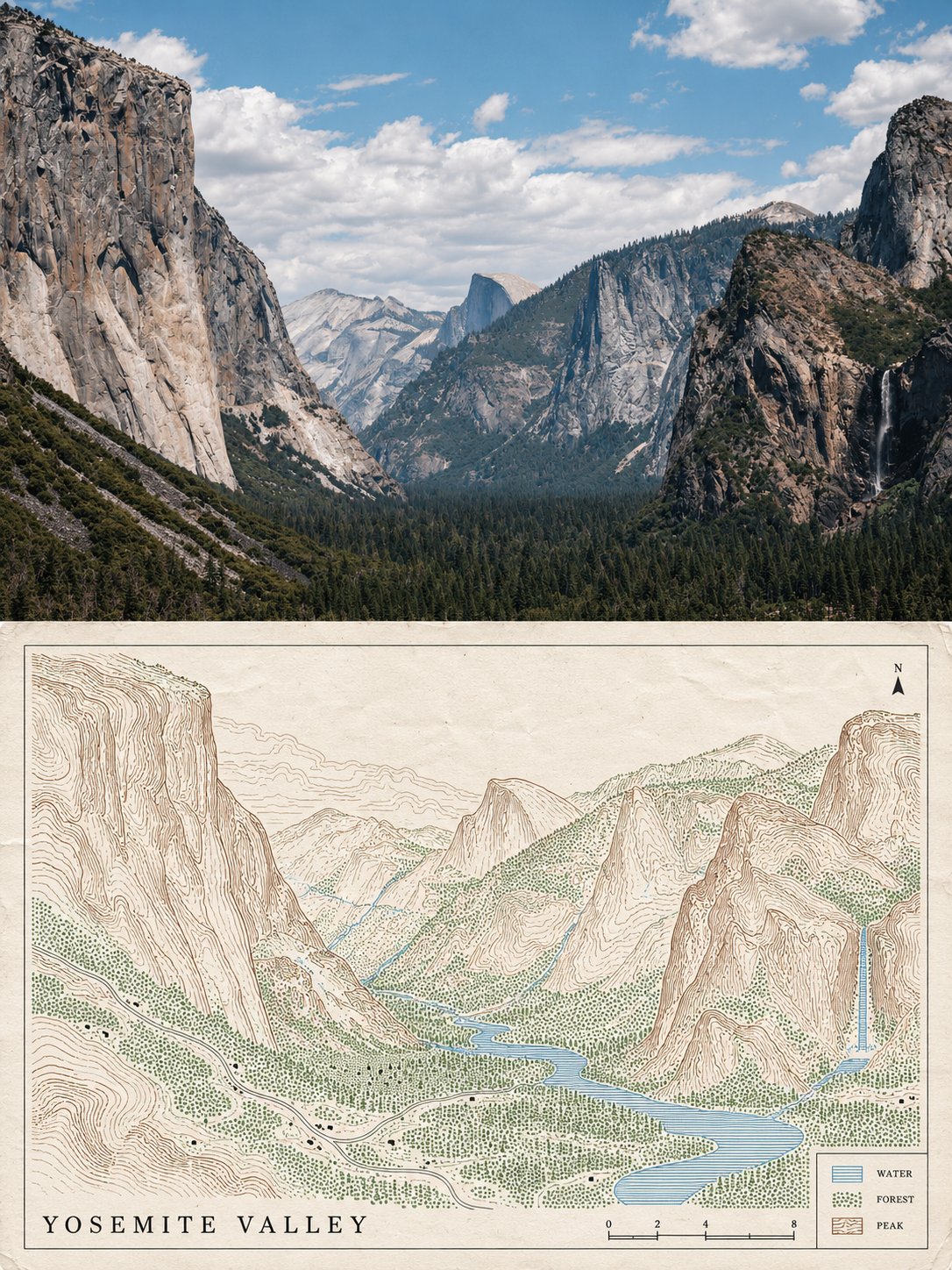
提示词
English
Please process each photo I upload into an independent high-end design poster, no multi-image stitching, each photo output individually. The overall composition uses a 3:4 vertical layout, with the upper and lower regions strictly 1:1 in height, each occupying 50% of the screen.

The upper half preserves the original photo, maintaining the subject's identity, structure, posture, realistic texture, natural light and shadow, and the original color atmosphere, only performing slight high-end color grading to give it the texture of an art magazine, independent publication, or exhibition image. To adapt to the frame, the environmental background can be naturally extended, but the subject must not be stretched, distorted, or changed. The upper half only contains the uploaded photo itself, following the original framing, without adding any text, borders, or graphics.

The lower half extracts the most recognizable scenes, terrain, and feature positions from the photo and reconstructs them into a map: the scenery in the photo is mapped one-to-one according to position, drawn as a cartographic-style topographic map. Ridges and mountains are circles of brown contour lines (the higher the lines, the denser and darker the color), the water surface is a blue fine horizontal line mesh, forests or grasslands are light green dot matrices, houses and buildings are small black squares, and roads are thin lines. No realistic features are drawn.

The composition follows "one map, one legend": the map fills about three-quarters of the lower half, with a thin border around it; the positions of the features in the map are consistent with the photo (the mountain on the left in the photo is on the left in the map, the water is at the bottom, etc.); a small legend is left in the lower right corner, containing three small color blocks plus very short descriptions, with a scale bar next to the legend; there is a small north arrow in one corner of the map. The surrounding paper surface is left white.

Only four colors are used: brown (contour lines), blue (water), light green (vegetation), near-black (buildings and lines), purified after sampling colors from the photo; the paper is an extremely light creamy white; flat colors, thin lines.

The material is a printed map: thin lines are clear, contour lines have extremely slight manual fluctuations, the paper surface has extremely fine fibers, and the edges have slight creases; no gradients or realistic shadows.

Text only appears on the map: one line for the map title (all-caps English name of the location extracted from the photo), numbers on the scale bar, three very short all-caps English words in the legend (such as WATER, FOREST, PEAK), and the letter N on the north arrow. Apart from this, no other text, letters, numbers, or logos appear in the frame.

Overall presentation shows a visual relationship of real photography × topographic map, clean, precise, quiet, with a sense of exploration. Avoid realistic landscapes, gradients, complex decorations, multiple legends, commercial advertising copy, and a template feel.
中文
请将我上传的每一张照片分别制作成一张独立的高级设计海报,不多图拼接,每张照片单独输出。整体采用3:4竖版构图,上下两个区域高度严格1:1,各占画面50%。

上半部分保留原始照片,保持主体身份、结构、姿态、真实质感、自然光影和原有色彩氛围,仅进行轻微高级调色,使其具有艺术杂志、独立出版物与展览图像质感。为适配画幅,可自然扩展环境背景,但不得拉伸、扭曲或改变主体。上半部分只放上传的照片本身,沿用原有取景,不添加任何文字、边框或图形。

下半部分提取照片中最具识别性的场景、地势与景物位置,重构为一张地图:把照片里的景色按位置一一对应,画成一幅制图风格的地形图。山脊和山体是一圈圈的棕色等高线(越高线越密、颜色越深),水面是蓝色的细横线网纹,森林或草地是淡绿色的点阵,房屋和建筑是小小的黑色方块,道路是细线。不画任何写实的景物。

构图遵循“一张图、一块图例”:地图占满下半部分约四分之三,四周有一圈细边框;地图内景物的位置与照片一致(照片里偏左的山在地图上偏左,水面在下方,等等);右下角留一小块图例,里面有三个小色块加很短的说明,图例旁有一条比例尺;地图一角有一个小小的指北针。周围纸面留白。

配色只用四种:棕色(等高线)、蓝色(水)、淡绿(植被)、近黑(建筑和线),从照片中取色后提纯;纸面是极浅的奶白;颜色平涂,线条纤细。

材质是印刷的地图:细线清晰,等高线带极轻微的手工起伏,纸面有极细的纤维,边缘有轻微的折痕;不要渐变和写实的阴影。

文字只出现在地图上:图名一行(从照片提炼的地点的全大写英文名)、比例尺上的数字、图例里的三个很短的全大写英文词(如 WATER、FOREST、PEAK)、指北针上的字母 N。除此之外画面中不出现任何文字、字母、数字或标志。

整体呈现真实摄影 × 地形图的视觉关系,清爽、精确、安静、有一点探索感。避免写实的风景、渐变、复杂的装饰、多个图例、商业广告文案和模板感。